NIT Rourkela and TIH IIT Patna Patent India’s First Real-Time Land Mapping Drone System
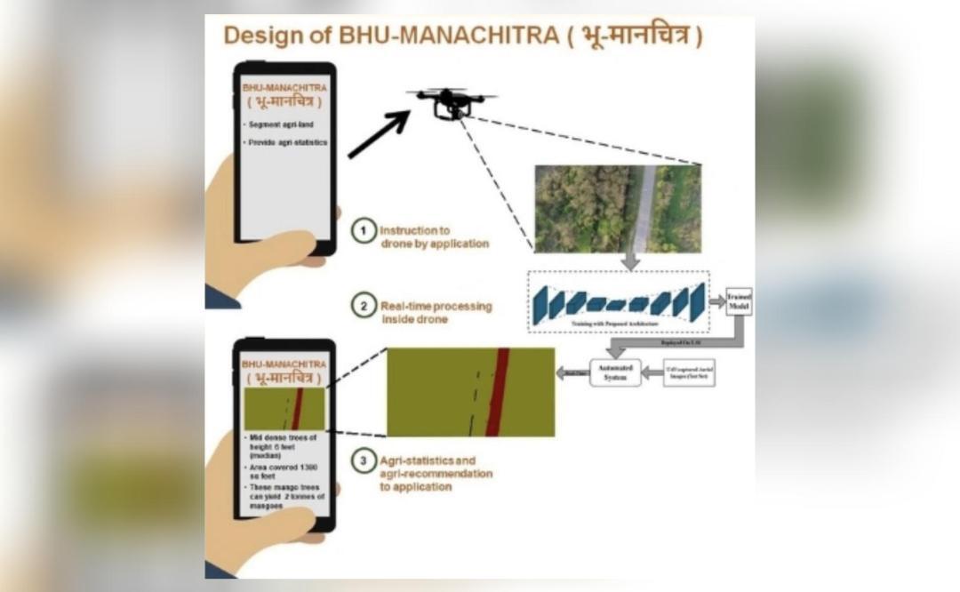
In a significant advancement for technology and land management, the National Institute of Technology (NIT) Rourkela and the Technology Innovation Hub at the Indian Institute of Technology (IIT) Patna, known as Vishlesan I-Hub Foundation (TIH IIT Patna), have jointly received a patent for India’s first autonomous real-time land mapping drone system. This innovative system, named ‘BHU-MANACHITRA’, is designed to generate accurate maps without the need for internet connectivity or manual intervention.
Overview of the BHU-MANACHITRA System
The BHU-MANACHITRA drone system employs lightweight artificial intelligence (AI) models in conjunction with unmanned aerial vehicle (UAV) technology. This combination allows for efficient and effective land mapping, making it particularly advantageous in remote and underserved regions where traditional mapping methods may be impractical.
Key Features of the BHU-MANACHITRA
- Autonomous Operation: The drone operates independently, eliminating the need for continuous human oversight.
- Real-Time Mapping: It generates maps in real-time, providing immediate data for analysis and decision-making.
- No Internet Required: The system functions without internet access, making it suitable for use in areas with limited connectivity.
- Lightweight AI Model: The integration of a lightweight AI model ensures that the drone is efficient and capable of processing data quickly.
- UAV Technology: The use of UAV technology allows for high-resolution aerial imagery, which is crucial for accurate land mapping.
Importance of the Technology
The development of the BHU-MANACHITRA drone system is a groundbreaking achievement with numerous implications for various sectors. Here are some reasons why this technology is important:
1. Enhanced Agricultural Practices
Farmers can utilize the drone’s mapping capabilities to monitor crop health, assess land conditions, and make informed decisions regarding irrigation and fertilization. This can lead to increased productivity and sustainability in agriculture.
2. Disaster Management
In the event of natural disasters, timely and accurate mapping can aid in assessing damage and planning recovery efforts. The ability to operate in remote areas without internet access is particularly valuable during emergencies.
3. Urban Planning and Development
Urban planners can leverage the drone’s capabilities to gather data for infrastructure development, zoning, and land use planning. This can enhance the efficiency of urban development projects.
4. Environmental Monitoring
The system can be employed to monitor environmental changes, track deforestation, and assess the impact of climate change. This data is crucial for conservation efforts and policy-making.
Research and Development
The successful patenting of the BHU-MANACHITRA system is a testament to the collaborative efforts of researchers at NIT Rourkela and TIH IIT Patna. The research team has worked diligently to develop a system that meets the needs of various stakeholders while pushing the boundaries of technology in land mapping.
Future Prospects
The patent for the BHU-MANACHITRA drone system opens up new avenues for research and development in the field of UAV technology and AI applications. It is expected that further enhancements will be made to improve its functionality and expand its applications. The collaboration between academic institutions and industry partners can lead to innovations that will benefit society at large.
Conclusion
The patent awarded to NIT Rourkela and TIH IIT Patna for the BHU-MANACHITRA drone system marks a significant milestone in India’s technological landscape. As the world continues to embrace automation and AI, innovations such as this will play a crucial role in shaping the future of land management and mapping.
Note: The information in this article is based on data available as of October 2023 and may be subject to change as new developments occur.